
Ski Vertigo Blog · 29 November 2024
Updated for the 2026/27 season.
Val Thorens sits at 2,300 metres at the head of the Belleville valley, the highest resort in Europe and the high point of the 3 Vallées. Before you ski it, it pays to know the map. On this page you will find the current Val Thorens piste map, the key numbers for the ski area, and our pick of the runs worth building your day around.
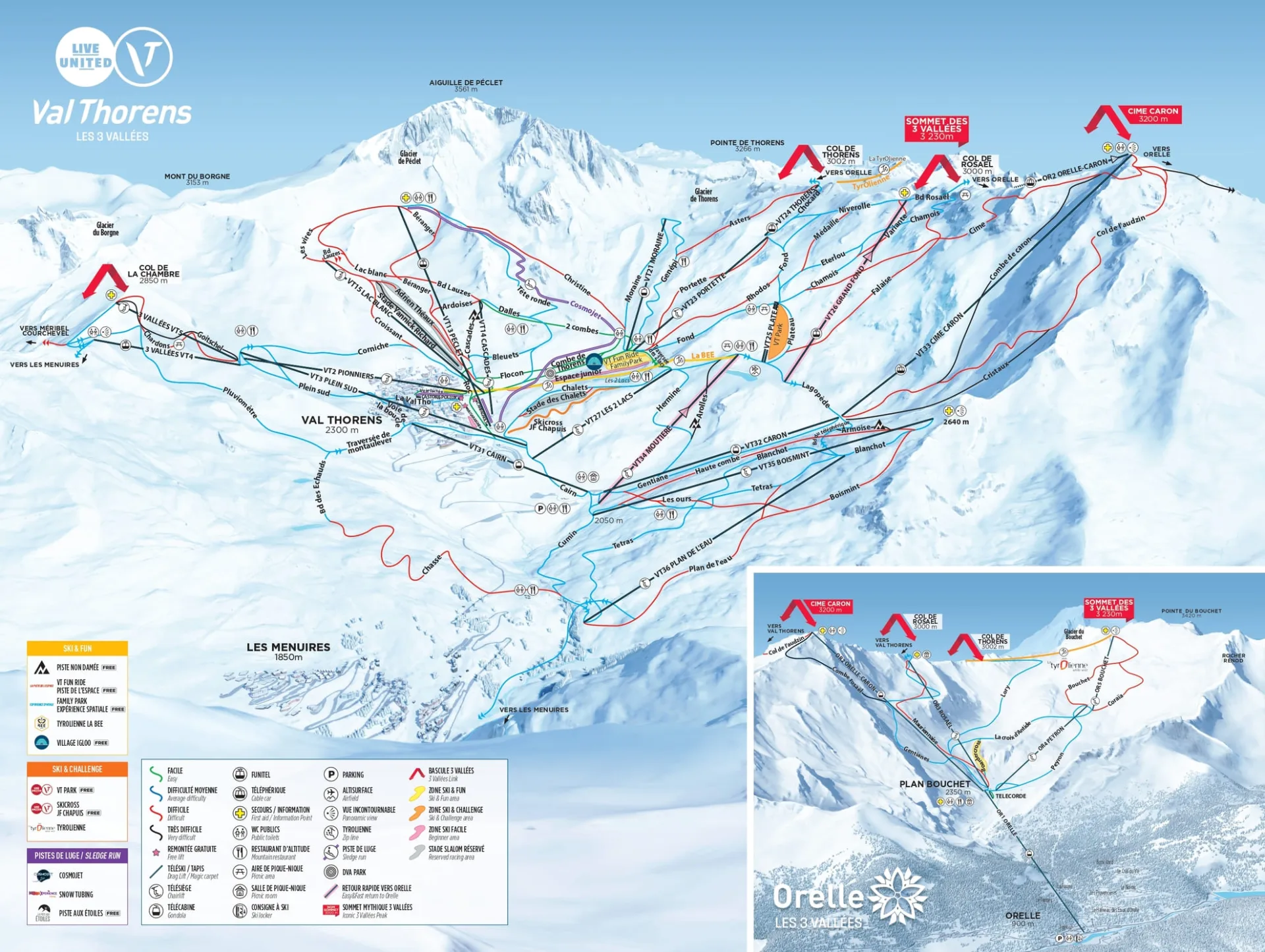
Download the Val Thorens piste map
The official Val Thorens-Orelle piste map is updated each season by the tourist office, with the full 3 Vallées map published alongside it. Both are available from the official Val Thorens piste map page, which also hosts the live interactive map showing which lifts and runs are open in real time. Prefer paper? Pick a copy up free from the lift pass offices and the Tourist Office in resort; most chalet operators, ourselves included, keep current copies for guests.
Val Thorens ski area at a glance
| Resort altitude | 2,300m |
|---|---|
| Ski area altitude | 1,825m to 3,230m |
| Pistes (Val Thorens-Orelle) | 150km |
| Pistes (3 Vallées) | 600km |
| Lifts in Val Thorens | 32 |
| Season | One of the longest in the Alps, opening earlier and closing later than the rest of the 3 Vallées |
How to read the piste map
French piste maps label lifts by type: TK is a drag lift, TS a chairlift, TC a gondola and TPH a cable car. Anything marked Express is a fast detachable chair. Runs follow the standard colour code, green to black. One habit worth forming: when you cross into Méribel or Courchevel, check the closing time of the return links before you set off. The last lifts back to Val Thorens close earlier than the pistes themselves, and a taxi home from another valley is an expensive way to end the day.
The best runs on the Val Thorens piste map
Once you have the map in hand, here is where we would point you first. For the complete rundown, see our guide to the best ski runs in Val Thorens.
For beginners
Plein Sud, in the heart of the resort, is wide and forgiving, with ample space to practise turns and stunning views while you do. Cascades is the natural next step: a longer, winding blue that rewards a little confidence with more varied scenery.
For intermediates
Boulevards, from the top of the Funitel de Thorens, is a long, flowing blue with views across the valley, ideal for working on your carving. Moraine, a red from the top of the Moraine lift, adds steeper pitches and varied terrain that will stretch a confident intermediate without ever feeling hostile.
For advanced skiers
Combe de Caron is the classic: a black from the Caron summit with a properly steep opening pitch and huge views before you drop in. Col de la Chambre is the other test, with moguls and narrow passages that reward strong technique.
Off-piste and viewpoints
The Glacier de Thorens is the best-known off-piste sector. Conditions change quickly up there, so carry the right equipment and consider a local guide. And whatever your level, ride to the Caron summit at least once: the observation deck gives a panorama across the surrounding peaks and valleys that is worth the lift ride on its own.
Ski the map from the door
Stay somewhere you can ski the map from the door. Our catered chalets in Val Thorens are ski in ski out, and our hosts keep current piste maps on hand for guests. And when the map day is done, see our picks for Val Thorens après ski and the best restaurants in Val Thorens.
Where can I get a paper piste map in Val Thorens?
Free from the lift pass sales points and the Tourist Office in the resort centre. Most hotels and chalet operators, ourselves included, keep current copies for guests.
Is the Val Thorens map the same as the 3 Vallées map?
No. The Val Thorens-Orelle map covers the local 150km sector in detail. The 3 Vallées map shows all the linked resorts and 600km of pistes at a smaller scale. Take both if you plan to explore.
How big is the Val Thorens ski area?
The Val Thorens-Orelle sector has 150km of marked pistes served by 32 lifts, with the widest choice of high, snow-sure skiing in the Alps thanks to a top height of 3,230m. The wider 3 Vallées network it links into adds up to 600km.
Ready to plan your ski holiday?
Catered chalets in Tignes, Val Thorens, Val d'Isère, Reberty 2000 and La Plagne.