What is a Piste Map
A piste map is essentially a top-down representation of a ski area: it shows lifts, runs or “pistes”, terrain zones, and key landmarks. The Tignes piste map helps you visualise where you can ski, how different areas connect, where good viewpoints lie, and how to navigate between villages. For families and groups, it’s a reassurance that everyone can find runs suited to their level. For solo travellers, it’s a way to plan quietly but confidently, knowing where to go.
But it’s not just practical, the Tignes piste map also hints at the resort’s geography. You’ll spot that the terrain rises dramatically, reaching up to the Grand Motte glacier, and you’ll see how the various villages from Tignes Les Brévières, through Tignes Le Lac and Le Lavachet, to Val Claret interlink with the ski area.
What’s in Tignes?
Tignes is a high mountain resort in the Savoie region of the French Alps, part of the combined Tignes–Val d’Isère ski area, which offers around three hundred kilometres of pistes. The resort sits at elevations ranging from roughly one thousand five hundred and fifty metres in its lower village, Tignes Les Brévières, up to three thousand four hundred and fifty-six metres on the Grand Motte glacier.
Tignes isn’t just one village, it’s made up of several distinct areas. Tignes Le Lac and Le Lavachet, often collectively referred to as “Tignes 2100,” are popular and well-connected. Higher still, you’ll find Val Claret, built in the 1960s, which provides direct access to the glacier terrain. Down below is Tignes 1800, and tucked away is the charming, more traditional Tignes Les Brévières.
Reading the Tignes Piste Map: A Simple Guide
When you open up the Tignes piste map, start by identifying the vertical scale, you’ll clearly see how height plays into the resort’s character. The highest runs hug the Grand Motte glacier, giving you long, high-altitude descents. The map marks lifts in different styles: the funicular, chairlifts, surface lifts, and cable cars. For example, the Funiculaire du Perce-Neige carries guests from Val Claret up to nearly three thousand thirty-two metres, a crucial gateway to glacier skiing.
Different colours represent difficulty levels: greens and blues for easier terrain, reds and blacks for steeper, more challenging runs. As you trace routes on the map, you can plan linked ski days or simpler, family-friendly circuits. Also look out for special symbols: viewpoints, pedestrian paths, and fun zones make the map not just for skiing but for exploration.
One very helpful part of the Tignes piste map is how it shows must-see viewpoints. These are not always obvious when you’re on the mountain, but when you consult the map, you can plan moments to pause, appreciate the landscape, and truly ‘be’ in the Alps rather than just ski through them.
Viewpoints & Landmarks
Exploring Tignes isn’t just about skiing, the resort is framed by some truly dramatic peaks, which also show up on the Tignes piste map. Among the most striking are the “three Grandes Dames”: Grande Motte, with its glacier that has become a symbol of the resort; Grande Casse, whose ridgeline towers sharply; and Grande Sassière, which in summer is accessible via hiking.
One of the most memorable viewpoints is around the summit areas served by the funicular and cable car. As you reach the top, the vista expands over the glacier and across other high mountain summits. The Tignes piste map is more than a tool for skiers; it becomes your guide to the mountains.
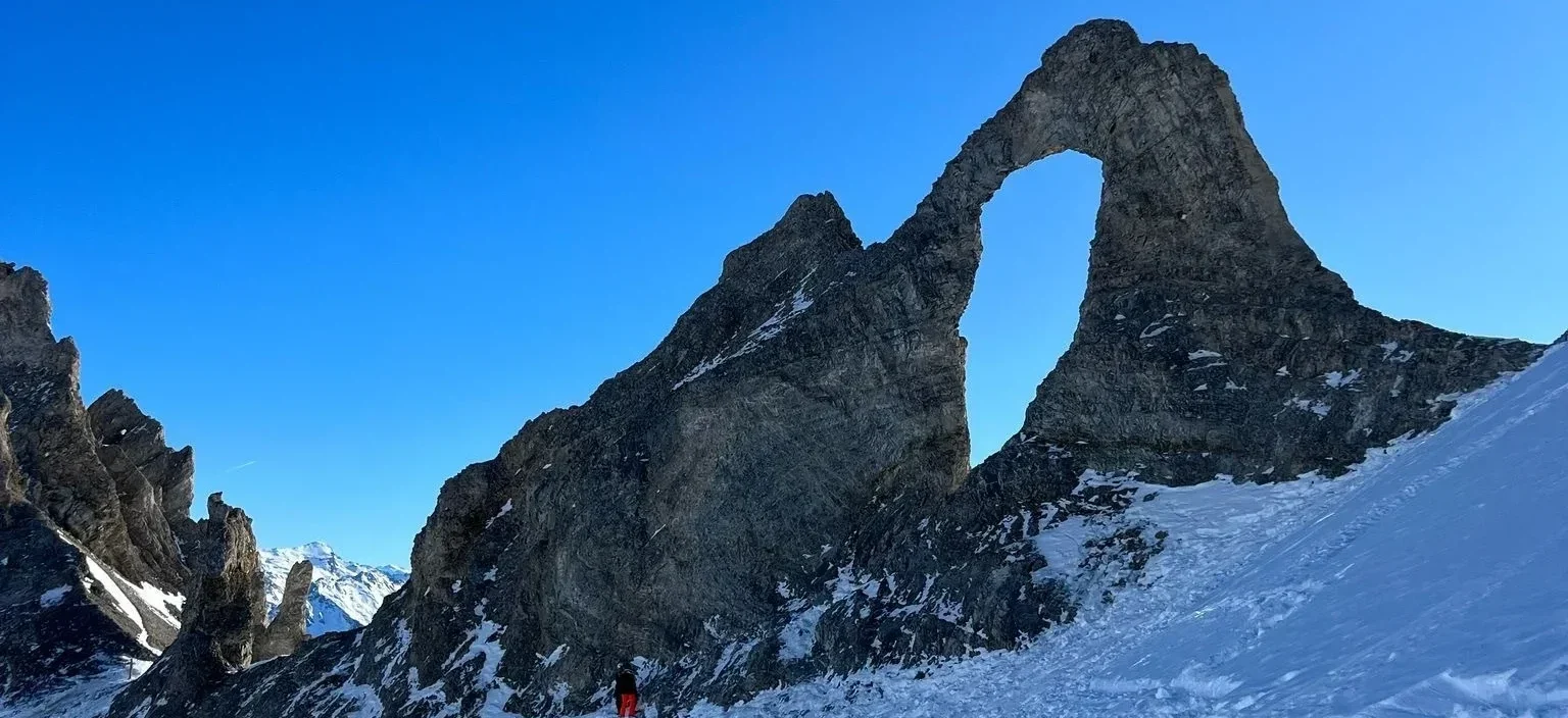
Some skiers also talk about a spot known informally as the “Eye of the Needle.” This rock formation is near the Aiguille Percée lift and is visible from certain pistes. It’s a striking natural feature, when you look at the Tignes piste map, you can trace your route to it, making it a target for more than just skiing, but also sightseeing. This spot is a lovely place to stop, look back, and appreciate how vast the terrain really is.
Why Use the Tignes Piste Map
For families, the Tignes piste map allows you to visualise gentle areas where beginners can ski in safety, while more experienced skiers plan longer, steeper runs. The map helps you decide where to base yourself: if you stay in Val Claret, for instance, you’re very close to high-altitude terrain, glacier lifts, and the funicular; from Le Lac or Le Lavachet, there is excellent access plus a warm, sociable village atmosphere.
Non-skiers appreciate the map because it shows more than pistes, it reveals where walking lifts run, where viewpoints are, and where you might ride up simply to pause and drink in the alpine panorama. Even in winter, lifts are often open for pedestrians, giving great access to scenic terraces high above the resort.
If you’re planning to stay in a catered chalet, using the Tignes piste map helps plan the best days to explore, when to head high for views or skiing, and how to mix in non-skiing moments. That way, your stay isn’t just about skiing, it’s about being part of the alpine landscape.
Tips for Making the Most of the Tignes Piste Map
Start by viewing the interactive version of the Tignes piste map available at the resort, which shows lift and piste status, weather conditions, and fun zones. That’s especially useful for families who need to adapt plans to snow conditions, or for someone wanting to choose the quietest lifts during the day.
Use the paper version too. Even in the age of apps, a physical piste map picked up from the tourist offices is a classic and dependable way to orient yourself. When you hold it in your hands, you get a real sense of elevation, scale, and how everything links.
When you’re up on the mountain, refer to the map frequently. If you’ve planned to ski down from the glacier or reach a viewpoint, knowing which lift connects where and which run to take back gives you confidence. Use the map to pick out intermediate zones, quieter terraces or lesser-known lifts, and incorporate them into your day.
Your Tignes Adventure awaits..
If you want to make the most of your next ski holiday in Tignes, familiarising yourself with the Tignes piste map is a great place to start. It helps you understand the geography, navigate the different villages, spot viewpoints, and make smarter decisions whether you’re skiing or exploring on foot.
By using the Tignes piste map as your guide, you can plan a balanced and thoughtful holiday: plenty of ski time, some moments just to soak up the view, and a sense of connection to this stunning part of the Alps. And when you’re ready to book, we’re here to help make it as hassle‑free and enjoyable as possible in one of our catered chalets!